
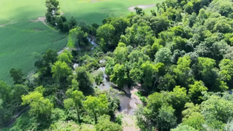
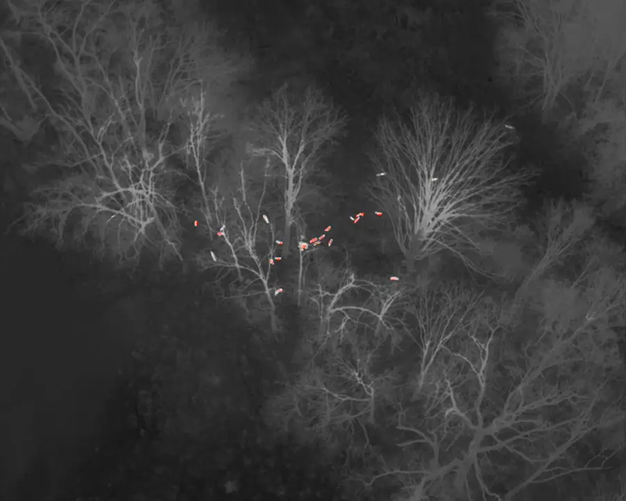
 Sample thermal footage
Count the herd you actually have
River bottoms, ridges, hollows, and timbered creek bottoms make it tough to know what you are really carrying. Trail cameras cover a few spots. We fly your ground with a DJI Matrice 4T thermal aircraft on a planned grid, covering the whole tract from open farm ground to big timber, and you get a count of the deer and hogs that were on your land the day we flew.
- Total deer observed across the property
- Buck, doe, and fawn estimates
- Feral hog sounders located and counted
- A map showing where animals were found
- Results stored in your client portal, season after season
One per-acre price, no surprises
$3.00–$4.00 per acre
- All-in: flight, processing, and your count report
- $900 minimum
- No travel fee anywhere in our service area
No bait needed. A thermal count works in CWD-zone counties where baiting is restricted.
Request a DateThe best days go first
Deer counts fly November through March, and the best flying days book first: cool and cloudy, when thermal sees best. Reserve your date before November 1 and lock this season’s rate.
Booking three seasons? We’ll lock your per-acre rate for all three.
Download a sample report (PDF) · what you get after a count: herd numbers, Doe:Buck ratio, and next steps
How a thermal drone deer count works
- Scope the propertyWe talk through your acreage, boundaries, access, and what you want to learn: total numbers, buck-to-doe ratio, hog pressure, or all three.
- Pick the windowThermal counts are flown leaf-off, from late fall to early spring, in the cool hours when body heat stands out best against the ground. We plan around weather and your hunting schedule.
- Fly the whole propertyThe aircraft runs a systematic pattern over your ground and records thermal imagery the entire time. No bait, no drives, and nobody pushing through the woods.
- Count and classifyWe review the footage, count deer and hogs, and classify bucks, does, and fawns where they can be told apart.
- Deliver and archiveYou get a clear summary and a map in your private client portal. Fly again next season and the trend builds on its own.
A note on accuracy. A thermal count reflects what the aircraft observed during the flight. It is the most complete view most landowners have had of their herd, but it is still an estimate. Bucks are easiest to classify before antler drop, and heavy evergreen cover such as cedar or pine thickets can hide animals from any aerial sensor.
Deer census deliverables and turnaround
- A written summary: total deer observed, buck, doe, and fawn estimates, and hogs located
- A property map (PDF, plus KMZ for Google Earth or your hunting app) marking where animals were found
- Short thermal clips of notable groups when they help tell the story
- Everything stored in your client portal, so next season’s count lines up beside this one
Turnaround depends on acreage and weather. Every clip is reviewed by a person rather than left to software, and your proposal includes a delivery date so you can plan harvest around it.
Thermal drone census vs. trail cameras and spotlight counts
Trail cameras are great for patterning individual deer, but they only see the spots where they hang, and the same deer shows up again and again. Spotlight and road counts cover the edges of fields. A thermal flight covers the whole property in one flight, timber included, so it is the best tool for a total count and a buck-to-doe picture. Many clubs use both: the drone for the herd-wide number, cameras for the details. If you also want to plan food plots, stands, and access roads, pair your count with a LiDAR terrain map of your hunting land.
Why landowners in the CWD zone track herd numbers
Parts of northwest Alabama are in a Chronic Wasting Disease Management Zone set by the Alabama Department of Conservation and Natural Resources. Inside the zone, baiting and supplemental feeding of wildlife are not allowed, which makes traditional bait-and-camera counts hard to run.
That is one reason landowners and hunting clubs want a reliable way to keep tabs on how many deer they are carrying from year to year. A thermal flight needs no bait, no feeders, and no camera stations. The drone simply counts what is there.
Regulations change. For current CWD zone boundaries and rules, check Outdoor Alabama, or the Tennessee Wildlife Resources Agency for Tennessee rules.
We find the hogs, too
Feral hogs tear up food plots, fields, and pasture, and they bed down in thick cover during the day where you never see them. The same flight that counts your deer pinpoints hog sounders across your property, so you know where they are bedding and feeding and can go after them before they cost you more.
One count is a snapshot. Several are a plan.
A deer herd is never the same two years running. Counting each season gives you a picture you can actually manage by.
The herd changes constantly
Fawns drop, deer shift ground, and harvest and hard winters take their toll. Last year’s count does not tell you what is on your property today.
Ratios take years to move
You cannot fix a lopsided buck-to-doe ratio in one season. Counting yearly lets you adjust doe harvest over time and see whether it is working.
Smarter harvest decisions
Head into the season with a real number behind your doe harvest plan instead of a guess.
See the trend, not just a number
One year is a dot. Several are a line: population, fawn recruitment, and ratio, all in your portal.
Where we fly
Based in the Shoals, serving North Alabama and Southern Tennessee. Not sure if your land is in range? Call or text and ask.
Drone deer census FAQ
How much does a drone deer count cost?
$3.00–$4.00 per acre, all-in: flight, processing, and your count report. $900 minimum. No travel fee anywhere in our service area.
When is the best time to do a thermal deer count?
Leaf-off, from late fall through early spring. With the leaves down and cooler temperatures, body heat stands out clearly against the ground. Earlier in that window is better if you want bucks classified before antler drop. We schedule around weather and your hunting plans.
Do I need to put out corn or bait for the count?
No. The drone counts deer wherever they are on the property. That matters in the parts of northwest Alabama inside the state's CWD Management Zone, where baiting and supplemental feeding are not allowed.
Can a drone tell bucks from does?
Often, yes. Antlered bucks are easiest to identify before antler drop, so earlier flights in the season give the best buck-to-doe picture. Fawns are estimated by body size. When an animal cannot be classified with confidence, we say so rather than guess.
Will thermal work in thick hardwood hollows?
Leaf-off hardwoods are where thermal works well, because the camera sees through bare branches. Dense evergreen cover such as cedar or pine thickets can hide animals, and we will tell you up front if part of your property is likely to be hard to see.
Do you count hogs too?
Yes. The same thermal flight that counts your deer also locates feral hog sounders, so you can see where they are bedding and feeding.
Do you fly in Tennessee as well as Alabama?
Yes. We are based in the Shoals, serving North Alabama and Southern Tennessee, and hunting land on both sides of the state line is part of our regular service area.
Book this season’s count
Leaf-off dates fill up. Call or text (662) 213-6441 or send a few details about your property, and we will put together a proposal.