Drone LiDAR in North Alabama: a photo shows treetops, LiDAR shows the land
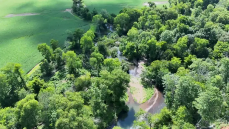
Much of North Alabama and Southern Tennessee is wooded: creek hollows, timbered ridges, and farm edges that disappear into hardwoods. A standard aerial photo map can only model the canopy. LiDAR sends laser pulses from the aircraft, and the ones that slip through gaps in the leaves reach the ground. From those ground returns we build a bare-earth surface that shows the real shape of the land under the trees.
We fly a DJI Zenmuse L3 LiDAR sensor on a DJI Matrice 400 enterprise drone, and pair it with high-resolution imagery from our DJI Matrice 4E mapping aircraft when a project calls for a sharp orthomosaic.
Flights use RTK/PPK positioning, and we set ground control points (GCPs) and independent check points when the project calls for them, so your surveyor or engineer can see how the data ties in. The result is mapping-grade data delivered in formats your surveyor or engineer can drop straight into their workflow, in the units and coordinate system they specify.
What drone LiDAR topographic mapping gives you
Bare-earth DTM
The terrain with trees and structures removed, for drainage analysis and for reading ridges, benches, and old roadbeds hidden in the woods.
1 ft & 2 ft contours
Contours at the interval your project needs, CAD-ready for plans or overlaid on aerial imagery.
DSM & elevation models
Elevation rasters of the ground and of the canopy or built surface (DSM), for slope, cut/fill, and drainage analysis.
Orthomosaic
A to-scale GeoTIFF aerial map of the whole site that you can measure from directly, and dated imagery for your records.
Classified point cloud
Ground, vegetation, and structure classes in the point cloud, plus a 3D view of the site you can rotate and share.
Files your team can use
Standard GIS and CAD formats for your surveyor, engineer, or GIS team, plus easy-to-view versions in your client portal.
Deliverables
- Orthomosaic (GeoTIFF), plus KMZ for Google Earth
- DSM and bare-earth DTM (GeoTIFF)
- Classified point cloud (LAS/LAZ)
- 1 ft and 2 ft contours, CAD-ready (DXF/DWG) or shapefile
- Delivered in the units and coordinate system your engineer or surveyor specifies
How drone LiDAR topographic mapping works
- PlanWe confirm the project limits, the deliverables, the contour interval, and the coordinate system, and check airspace and site access.
- Set controlWhen the project calls for it, we set ground control points and separate check points, or tie into control your surveyor provides.
- FlyThe aircraft flies a planned grid with RTK/PPK positioning, ideally leaf-off for the most ground returns under the trees. Leaf-on flights still work. LiDAR reaches the ground through hardwood canopy, so there’s no need to wait for winter to get started.
- ProcessWe process the trajectory, classify the point cloud into ground, vegetation, and structures, and build the DTM, DSM, contours, and orthomosaic.
- DeliverFiles go to you or your engineer in the formats you asked for, with viewable versions in your client portal.
Turnaround depends on acreage, vegetation, weather, and the deliverables. Processing and classification take longer than the flight itself. Your proposal lists a delivery date, and if a design team needs a preliminary orthomosaic ahead of the full package, just ask.
Drone LiDAR vs. photogrammetry, public LiDAR, and a licensed surveyor
- Photogrammetry (photo mapping) is the better value on open ground, active job sites, and stockpiles, where the camera can see the surface. See earthwork and stockpile volume mapping.
- Drone LiDAR is the right call for wooded or brushy ground, where you need the bare earth under the canopy.
- Free public LiDAR is worth a first look, but it may be years old and less dense than a fresh drone flight, and it will not show recent clearing, grading, or ponds.
- A licensed land surveyor is required for boundaries, legal descriptions, stamped topography, and construction staking. Drone data supports that work; it does not replace it.
Who uses it
- Landowners evaluating wooded acreage before a purchase, timber sale, or build
- Pond, dam, road, and trail planning on rural property
- Surveyors and engineers who need pre-construction topo and early-stage terrain for concept work
- GIS teams adding bare-earth surfaces and contours to their mapping
- Drainage analysis and erosion questions where the ground is hidden by trees
- Developers and builders sizing up a site before committing to full design
- Banks and lenders documenting timber and farmland tracts, or supporting appraisals with dated imagery
Planning data, not stamped work
Our LiDAR and mapping products are planning and design-support data. They are not certified or stamped, do not establish property lines, and are not a substitute for a licensed Professional Land Surveyor or Professional Engineer.
Drone mapping complements, but does not replace, the work of a licensed land surveyor. On projects that need stamped work, we work alongside your surveyor or engineer: we collect the aerial data, and they set or verify the control and certify the final product.
Where we map
Based in the Shoals, serving North Alabama and Southern Tennessee. Rural acreage, development sites, and wooded tracts across the region. Hunting land owners often pair a terrain map with a thermal deer and hog census.
Drone LiDAR FAQ
How much does drone LiDAR mapping cost?
Every project is quoted by acreage, terrain, vegetation, and the deliverables you need. There are no set package prices. Call or text for a proposal.
How accurate is drone LiDAR?
Drone LiDAR produces dense, detailed terrain data, and its accuracy depends on RTK/PPK positioning, ground control points, check points, and processing. It is not certified or stamped work. When your project needs stamped work, we collect the aerial data and coordinate with your licensed surveyor or engineer.
Can LiDAR really see through trees?
In a sense, yes. Laser pulses pass through gaps in the canopy and some reach the ground, which is how we build a bare-earth surface under the woods. Leaf-off conditions help, and very dense evergreen cover limits how much ground is captured.
What is the difference between LiDAR and a drone photo map?
A photo map (photogrammetry) shows what the camera can see: rooftops, pavement, and the tops of trees. LiDAR measures the ground underneath vegetation. For wooded land we often deliver both.
How long does it take to get my maps?
Field time depends on acreage and weather, and processing depends on the deliverables. You will get a delivery timeline with your proposal.
Map the ground under your trees
Send a boundary or a rough acreage and what you need the data for. Call or text (662) 213-6441 for a proposal.